

These lines were discovered by Mr Rob Farrer and Co during their time of discovering the island with metal detectors. It is thanks to Rob’s study and work with leys, that most of his findings from metal detectoring in the Island’s museums were discovered.
His mappings pinpoint the start at a landbridge which no longer exists.
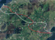
Line 1
The first point reads:
“Landbridge connections. English Coast to Manx Coast, 10,000 years ago.”
Following this line south along the west coast of the island, the next marker note reads:
“Cronk Urleigh is known Tynwald and forms a triangle with St John’s and Old Tynwald.”
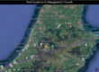
After Tynwald Hill, the next marker is at Cronk ny Arrey Laa and reads:
“Watch Ward. It is said by some historians, that a big stone cairn on top of the hill, is one of the burial places of Manannan Mac Lir.”
It’s worth noting here that on the Island, there are two rumoured burial sites of Manannan; Cronk ny Arrey Laa and Peel Castle.
The line continues south to the Calf of Man, crossing the site where a shrine or keeill once stood, before ending on the south coast of the Calf.
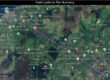
Line 2
The first marker on the second line reads:
“Phurt/Port Cranstall”
This point also crosses with a line that runs from Calanais Standing Stones in Scotland, to Mont St Michael in France.
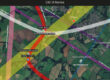
The line continues south crossing Kirk Christ Lezayre Church, passing an area Rob has identified as The Sheilings with the note:
Are these one of two tracks over 10,000 years old and used by the hunter gatherers? Hoof prints of young boar found at Phurt
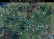
The line runs close to the summit of Beinn-y-Phott and through a farm at East Baldwin, just east of the site of St Luke’s Church and the site known as the ‘original Tynwald Hill’.
It is this farm at East Baldwin, only a few fields away from the original Tynwald Hill, where up to 9 lines cross the Island from the UK and Ireland.
Further south, the line passes Glen Vine and a marker from the Ordinance Survey map noting “St Patricks Chapel and Keil”
Continuing south, the next marker the lines passes through is St Sanctain’s Church as a site marked by Rob a few yards away that reads:
House of Bones
A shrine in the shape of vseehme(?) ruildino(?) was a top quian(?) stone with a hole to allow the Saint bones to be touched.
Keeill and shrine taken when house was built.
The line the continues through the south circle of Arragon Moar stone circles, through the sites of a now long gone chapel, keeill, burial ground and fort, before ending on the south-west tip of Langness.